
One Nation, Under God
One Nation, Under God
The National Weather Service hosted their November Weather-Ready Briefing for Eastern Montana and Wyoming last week and talked of the year-to-date climate review, drought status, and both short and long-term weather range outlooks for the areas.
Patrick Gilchrist, National Weather Service Glasgow, Mont., Office, said that last October was the 39th coolest in Montana on record and colder than usual, but said that November's weather in the state was closer to average.
October's precipitation totals in Montana crept toward what is normally expected during the 10th month of the year and provided some much-needed drought relief in Montana, especially in the Phillips, Blaine and Hill Counties. November's precipitation followed October and aligned with normal amounts.
"There are some spotty areas of precipitation," Gilchrist said. "The Billings area and the south-central area (of Montana) have really seen much above average perception totals for the year ...while along the Hi-Line, we saw more normal conditions but it didn't all come at the times we needed it to for drought impact."
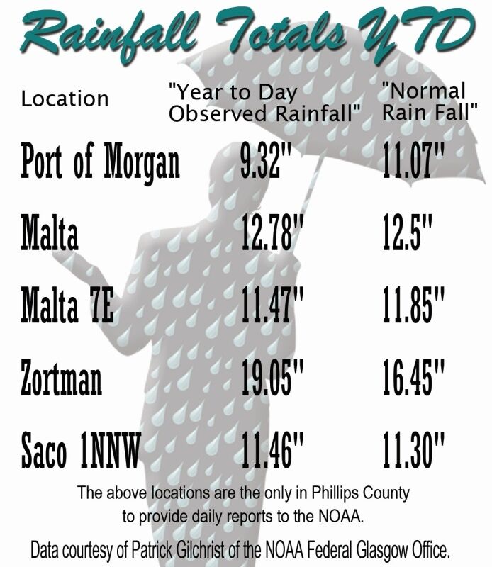
Gilchrest compared Glasgow and Billings where Glasgow's total precipitation to this point in 2018 totals 10.55' (.66' below normal) and Billings has had 18.29" which is 5.22" above normal (see a chart on page one for some Phillips County precipitation totals.)
"We saw those persistent droughts across much of Phillips County, Blaine, and Hill Counties through the summer months," he said, "but the precipitation that has fallen this Fall has really allowed us to taper some of those drought conditions back ...with just a sliver of Phillips County being affected."
Gilchrist added that it looks like drought conditions will continue to improve in those three counties.
Looking ahead, Gilchrist said that December looks to be warmer than usual as the month progresses with good chances for precipitation, deviating from the warmer El Nino that has been predicted for this winter. The core months of winter - December, January, and February - are all trending toward warmer than usual with average precipitation totals for those three months.
"That's a pretty substantial change from the warmer, drier signal we were picking up for the El Nino and it looks like we will get more precipitation which would be good since we have some areas that are dealing with drought still," he said.

Reader Comments(0)