One Nation, Under God

Wondering About the Weather?

Though Spring Has "Started", Winter Still Present

Through correspondence with the National Weather Service (NWS) in Glasgow an inquiry was made as to the outlook on the recent weather and what lies ahead. The question posed is in BOLD and the NWS response follows.

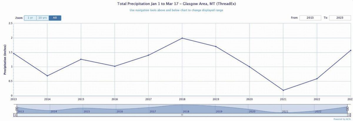
How does this year compare to precipitation over the last 10 years?

From January 1st through March 18th, the amount of precipitation has been much higher than in 2021 and 2022. The graphic below has precipitation in inches on the y-axis, and the year on the x-axis going back to 2013. 2023 is currently in the top 3 over the past ten years for total precipitation. Well below average temperatures are expected through the end of March, and snowfall observed in 2023 thus far may lead to minor to moderate flooding in April for locations along the Milk River. This is if temperatures increase significantly in a short amount of time in April.

Across Phillips County, do you have any reported snow accumulation for this year? For the last 2 weeks?

Provided on Graph 2 (page 8A) are graphics of the snowfall for the season beginning in the fall of 2022 for Phillips County. The first graphic indicates seasonal snowfall on March 2nd. The second graphic (also on Page 8A) indicates seasonal snowfall on March 17th. We do not have data for exact snowfall amounts in Phillips County as a whole for the past two weeks, but the third graphic below indicates the past two weeks of snowfall for Malta if this is at all helpful. One caveat is the third graphic doesn't include the most recent snowfall that occurred on March 15th and March 16th.

Are we still considered a drought stricken area?

We have seen recent improvements in drought based on recent snowfall for much of northeast Montana, but we are still in a drought. The Climate Prediction Center (CPC) graphic below indicates moderate to extreme drought for the area currently, but the graphic is a little misleading when it comes to snowfall. Future outputs of the drought monitor graphic (Graph 3 on Page 8A) will indicate improvement in the drought when the snowfall has been melted and absorbed by the soil. Once the snow melts, the CPC drought monitor will indicate improvement in the drought conditions.

Where have you seen the greatest accumulation of snow along the hi-line?

The greatest accumulation of snow has occurred along the Milk River from Chinook to Saco northward to the Canadian border. Pockets of snow depth from 4 to 6 inches, and even 6 plus inches exist in that area. This is according to the Advanced Hydrologic Prediction Service (AHPS) snowfall analysis.

If we are not out of drought classification, what are we looking at to be close to what is needed for ample moisture?

With the high amount of recent snowfall, there is likely enough moisture to slightly improve the drought classification. However, this will not be reflected in future climate outlooks until snowfall has begun melting, and the melted snowfall has begun filtering into the soil. We will likely need much higher moisture over the next year to fully relieve drought conditions, but we cannot say exactly how much moisture will be needed.

Please share any information that might be pertinent to this matter. Is the staff keeping busy with this deluge of snowfall?

The staff has kept plenty busy with the snowfall! The main concern from all this snowfall is the hydrologic outlook for this spring. Temperatures are expected to be well below average through the end of March. This brings three concerns to the table. For one, a rapid warm-up in April could lead to rising streams and minor to moderate flooding along the Milk River. This is due to the high snowfall amounts that have occurred over the winter season, as well as for March alone. Second, if a significant amount of rain falls on top of the existing snowpack, flooding along the Milk River could be made worse than is currently predicted. Third, a large snowfall event before the end of March could also make flooding even more of a concern in April. However, the Climate Prediction Center indicates up to a 60 percent chance of below normal temperatures for April 1st through April 14th, which may keep down the possibility of significant flooding. The bottom line: we will be busy keeping an eye on the flood.


Reader Comments(0)